Those Places Thursday: Carrick-on-Suir, Ireland, Birthplace of Dr. John H. O’Brien
Helbling Family (Click for Family Tree)
Finding the “Olde Country” home of one of our immigrant ancestors can be challenging, but thrilling when the tedious researching pans out. That was the case with learning that Carrick-on-Suir, in County Tipperary, Ireland, was the home of one of our immigrant ancestors.
Dr. John H. O’Brien’s tombstone indicates that he was born in Carrick-on-Suir, Ireland, in June 1808. Learning a bit about the town is a way for us all to ‘visit’ our ancestral homeplace without leaving the comforts of our home. (Though a trip to Ireland would be delightful!)
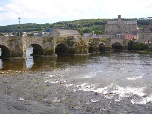
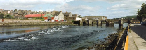
The Irish name of Carraig na Siúire means “rock of the Suir.” The town was built on both sides of the River Suir, in County Tipperary, Ireland.
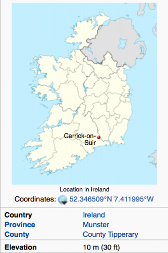
Located in the southeastern part of Ireland, the majority of the town is on the northern side of the river, and is known as Carrig Mór, or ‘Big Rock.’ A smaller section of the town, called Carrig Beg, for “Small Rock,” is situated on the southern side of the river. Although in a river valley, the town nestles up to one mountain, and has a beautiful view of rolling hills and mountains in many directions. (See some of the Google Images linked below, since they are copyrighted.)
Rivers were primary means of transportation for both goods and people for centuries, and the River Suir was no different. A canal towpath ran along the river at one point, and today is used as a riverwalk for recreation. The Suir is a tidal river, which means that even though Carrick-on-Suir is about 50 miles from the coast, the tides raise and lower the waters considerably as the tides come in and go out. (Note high water levels on some of the bridge pictures.) Flooding of the river valley does occur on a regular basis, and probably did more often in the years that the O’Briens lived there, since there was less engineering done to waterways back then. The elevation is only 30 ft. above sea level, and the town has had to build quays to hold back the tidal surge during stormy periods; global warming is a concern with rising sea levels.
Actually, they did more engineering back in the day than one might think. The town was originally founded on an island, possibly before the year 1247. Sometime in the 1700s, as the town grew and needed more land, small rivers were diverted to add to the buildable land both west and north of the town.
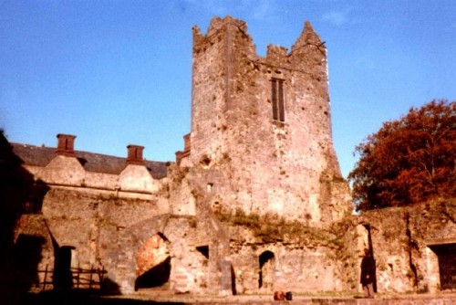
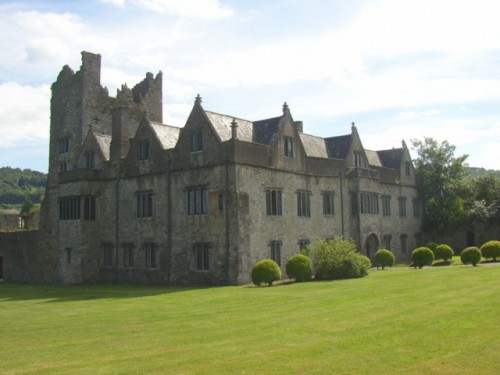
Two castles were built in the town (one in 1315, the second around 1450), and about 100 years later a manor house that was built around two of the old towers. The Manor House and ruins, also known as Ormond Castle, have more recently been renovated and are open for tours. Our John O’Brien would have seen these buildings in a more rustic state, and maybe played among the ruins as a young boy.
As with many places in Ireland, Carrick-on-Suir was prohibited from freedom of religion during much of its more recent history. (“Recent history” to the Brits is after 1500 or so.) The British closed down a Franciscan friary that had been in existence since the 14th century, and persecuted Catholics after Henry VIII began the Church of England. About 80% of the Irish were Catholics in those days, thus for centuries they had been prohibited from education, from owning or renting land, from holding a number of professions, etc. In 1829, ‘Catholic Emancipation’ allowed them freedoms again, but most still lived in poverty due to the laws imposed on their parents and grandparents. (John O’Brien would have been 21 years old then.) During John’s lifetime, the friary, a small church called St. Molleran’s Parish, which is even older, and a newer church, St. Nicholas’ Church, were all active Catholic churches, which was the religion we believe Dr. O’Brien practiced since he is buried in a Catholic cemetery.
The Carrick-on-Suir town clock was built in 1784. Since John was born in 1808, his parents likely were born circa 1780, so it would have kept the time for John and his family. Most of the residents back then were probably not wealthy enough to purchase their own timepiece.
A woollen industry had been developed in Carrick-on-Suir in 1670, and it drew in workers steadily. The wool industry, along with fishing and other river-related businesses that included basketweaving, helped the population to swell to about 11,000 by 1799, just 9 years before our ancestor John O’Brien was born. (Wonder if his father worked in one of these industries?) The British, however, did not want the Irish competing with their own wool industry, so high taxes and levies on wool and other products led to unemployment, poverty, and hunger. Emigration (often forced by the British, especially for those who were poor or convicted of crimes- even of stealing an apple!) to places such as the Americas, Australia, etc. was another result of British rule, and contributed to the depopulating of the area.
John H. O’Brien was one of those who left the town, but he migrated before the Great Famine, often known as “The Potato Famine.” County Tipperary lost 20-30% of its population due to death or emigration by the end of the famine, and in 2006 only had about 6,000 people.
We will detail more about the adult years of Dr. John O’Brien in a future post.
Notes, Sources, and References:
- See “Tombstone Tuesday- Dr. John H. O’Brien” at http://heritageramblings.net/2014/01/14/tombstone-tuesday-dr-john-h-obrien/ for more about the family.
- Some wonderful images of Carrick-on-Suir and maps can be found on Google Maps: https://www.google.com/maps/dir/Waterford,+Ireland/Carrick-On-Suir,+Co.+Tipperary,+Ireland/@52.295537,-7.4067322,39038m/data=!3m2!1e3!4b1!4m14!4m13!1m5!1m1!1s0x4842c69c63d9e44d:0xc5bb81888b67b9fb!2m2!1d-7.1100703!2d52.2593197!1m5!1m1!1s0x4842d6fc9619051f:0xa00c7a99731e910!2m2!1d-7.4189708!2d52.3476495!4e1
- St. Mary’s Cemetery at Carrick-on-Suir- perhaps the parents or other ancestors of John H. O’Brien are buried here? That needs to be on the research checklist.
https://www.google.com/maps/place/Carrick-On-Suir,+Co.+Tipperary,+Ireland/@52.3403584,-7.412284,3a,75y,34h,90t/data=!3m7!1e1!3m5!1sEdV89zUL6gtHa-769N8wJA!2e0!6s%2F%2Fgeo0.ggpht.com%2Fcbk%3Fpanoid%3DEdV89zUL6gtHa-769N8wJA%26output%3Dthumbnail%26cb_client%3Dmaps_sv.tactile.gps%26thumb%3D2%26w%3D203%26h%3D100%26yaw%3D34.386131%26pitch%3D0!7i13312!8i6656!4m2!3m1!1s0x4842d6fc9619051f:0xa00c7a99731e910!6m1!1e1 - Perhaps some of these downtown buildings existed in John O’Brien’s early years in Carrick-on-Suir?
https://www.google.com/maps/place/Carrick-On-Suir,+Co.+Tipperary,+Ireland/@52.346063,-7.413304,3a,75y,78h,90t/data=!3m8!1e2!3m6!1s29970615!2e1!3e10!6s%2F%2Flh3.googleusercontent.com%2Fproxy%2FePLOCG1aGr4gdN7ituRTIPJUWxXlhCHwIz2r5qB_6ea3tQmQ4LrVxWIqFesVk7gs_FBgiDmtziUnxYn9hvDUPFT-rf08JQ%3Dw203-h152!7i2272!8i1704!4m2!3m1!1s0x4842d6fc9619051f:0xa00c7a99731e910!6m1!1e1 - How many sunsets did John O’Brien watch over Slievenamon?https://www.google.com/maps/place/Carrick-On-Suir,+Co.+Tipperary,+Ireland/@52.34326,-7.411873,3a,75y,48h,90t/data=!3m8!1e2!3m6!1s92541761!2e1!3e10!6s%2F%2Flh3.googleusercontent.com%2Fproxy%2Fht3DDdu7HPxx4C4ww2T6X1luaKDuJFtsC4DtMX_ZQ5HEgFlkofALRCe2n8luZY4nfMlQi8oR_0CNGo8foolarXOfxV5JgQ%3Dw203-h135!7i800!8i534!4m2!3m1!1s0x4842d6fc9619051f:0xa00c7a99731e910!6m1!1e1
- Wikipedia articles consulted:
https://en.wikipedia.org/wiki/Carrick-on-Suir
https://en.wikipedia.org/wiki/Great_Famine_(Ireland)
https://en.wikipedia.org/wiki/Ormonde_Castle
- “Ormonde Castle – Caisleán Urmhumhan – geograph.org.uk – 924019” by James Yardley. Licensed under CC BY-SA 2.0 via Commons – https://commons.wikimedia.org/wiki/File:Ormonde_Castle_-_Caisle%C3%A1n_Urmhumhan_-_geograph.org.uk_-_924019.jpg#/media/File:Ormonde_Castle_-_Caisle%C3%A1n_Urmhumhan_-_geograph.org.uk_-_924019.jpg
- Ormonde Castle, or Caisleán Urmhumhan, from Manor House:
“Ormonde Castle – Carrick-on-Suir” by Humphrey Bolton. Licensed under CC BY-SA 2.0 via Commons – https://commons.wikimedia.org/wiki/File:Ormonde_Castle_-_Carrick-on-Suir.jpg#/media/File:Ormonde_Castle_-_Carrick-on-Suir.jpg - Carrick-On-Suir clock images can be found at https://www.flickr.com/search/?text=carrick%20on%20suir%20clock
- We have not yet been able to find records of John’s family actually in Carrick-on-Suir. There are quite a lot of John O’Briens listed as being born in County Tipperary, but since we do not know the names of his parents, it will be hard to determine exactly which records are for our John H. O’Brien. Perhaps he was born in a different town and then moved to Carrick-on-Suir when very young, so thought he was born there? More research needed.Please contact us if you would like higher resolution images. Click to enlarge images.